


介绍 Spyglass
Spyglass is an essential offline GPS app for outdoors and off-road navigation. Packed with tools it serves as binoculars, heads-up display, hi-tech compass with offline maps, gyrocompass, GPS receiver, waypoint tracker, speedometer, altimeter, Sun, Moon and Polaris star finder, gyro horizon, rangefinder, sextant, inclinometer, angular calculator and camera. It saves a custom location, navigates precisely to it later, shows it on maps and using augmented reality displays detailed GPS info, measures distances, sizes, angles, and does a lot more.
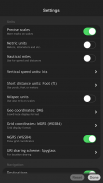
IMPORTANT NOTE ON ANDROID RELEASE
One of the best cross-country GPS navigation tools is now available on Android. Most features are implemented, however, some features available on other platforms are to be done. Also, instead of having multiple apps, on Android it is a single free app with a paid unlock of premium features. Be patient and report bugs, if any, directly via our email or the support page.
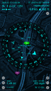
COMPASS & GYROCOMPASS
Accuracy improvement techniques, special compass modes and calibration methods available in Spyglass only make it a real instrument – the most advanced and accurate digital compass.
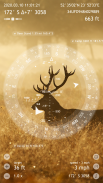
FINDER, TRACKER & AR NAVIGATION
Spyglass operates in 3D and uses augmented reality to show object positions, info and directions to them overlaid over camera or maps.
Save current position, add a point from maps, manually enter location coordinates.
Find the saved place later simply by following directional arrows.
Spyglass tracks your target and shows its info – distance, direction, azimuth, elevation and estimated time of arrival.
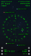
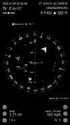
GPS, SPEEDOMETER & ALTIMETER
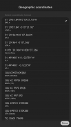
Find and track your location and get detailed GPS data – coordinates in dozens of formats, altitude, course, current, maximum and vertical speed, using imperial, metric, nautical and surveying units.
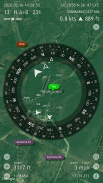
OFFLINE MAPS
See your and targets’ positions on maps using different map styles and alternative map providers – plan waypoints and measure distances. Offline maps optimized for retina displays are available for download.
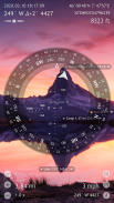
TRACK POLARIS, SUN AND MOON & NAVIGATE BY STARS
Track positions of Polaris, Sun and Moon with arc second precision – use them as a reference to calibrate compass for maximum accuracy.
OPTICAL RANGEFINDER
Measure distances to objects in real time with a rangefinder reticle similar to sniper sights.
SEXTANT, ANGULAR CALCULATOR AND INCLINOMETER
Find out heights of objects and distances to them – measure visually and calculate dimensions and distances.
CAMERA
Take pictures overlaid with all available GPS, positional and directional data.
DEMO & HELP
Videos:
http://j.mp/spyglass_vids
Manuals:
http://j.mp/spyglass_help
Spyglass是户外和越野导航的必备离线GPS应用程序。装有工具,可用作双筒望远镜,抬头显示器,带离线地图的高科技指南针,陀螺罗盘,GPS接收器,航点跟踪器,车速表,高度计,太阳,月亮和北极星探测器,陀螺地平线,测距仪,六分仪,测斜仪,角度计算器和相机。它保存了一个自定义位置,以后精确导航,在地图上显示它,并使用增强现实显示详细的GPS信息,测量距离,大小,角度,并做更多。
关于ANDROID RELEASE的重要说明
Android上现已推出最好的越野GPS导航工具之一。大多数功能都已实现,但是,其他平台上的某些功能尚未完成。此外,在Android上,它不是拥有多个应用程序,而是一个免费的应用程序,具有付费解锁的高级功能。请耐心等待并直接通过我们的电子邮件或支持页面报告错误(如果有)。
指南针和GYROCOMPASS
Spyglass中提供的精度改进技术,特殊罗盘模式和校准方法仅使其成为真正的仪器 - 最先进,最精确的数字罗盘。
FINDER,TRACKER和AR导航
Spyglass以3D模式运行,并使用增强现实技术显示物体位置,信息和方向,覆盖在相机或地图上。
保存当前位置,从地图添加点,手动输入位置坐标。
稍后通过按照方向箭头找到保存的地方。
望远镜跟踪您的目标并显示其信息 - 距离,方向,方位角,高度和预计到达时间。
GPS,SPEEDOMETER和ALTIMETER
查找并跟踪您的位置并获取详细的GPS数据 - 使用英制,公制,航海和测量单位的几十种格式,高度,航向,当前,最大和垂直速度的坐标。
离线地图
使用不同的地图样式和替代地图提供者查看您和目标在地图上的位置 - 计划航路点和测量距离。可以下载针对视网膜显示优化的离线地图。
TRACK POLARIS,SUN AND MOON&NAVIGATE by STARS
以弧度秒精度跟踪北极星,太阳和月亮的位置 - 使用它们作为参考来校准罗盘以获得最大精度。
光学范围
使用类似于狙击瞄准具的测距仪标线实时测量物体的距离。
SEXTANT,ANGULAR CALCULATOR和INCLINOMETER
找出物体的高度和距离 - 视觉测量并计算尺寸和距离。
相机
拍摄覆盖所有可用GPS,位置和方向数据的照片。
演示和帮助
视频:
http://j.mp/spyglass_vids
手册:
http://j.mp/spyglass_help


Spyglass - APK信息
APK版本: 3.9.9程序包: com.happymagenta.spyglass同类应用
您可能还会喜欢……


